This site uses cookies to improve your experience. To help us insure we adhere to various privacy regulations, please select your country/region of residence. If you do not select a country, we will assume you are from the United States. Select your Cookie Settings or view our Privacy Policy and Terms of Use.
Cookie Settings
Cookies and similar technologies are used on this website for proper function of the website, for tracking performance analytics and for marketing purposes. We and some of our third-party providers may use cookie data for various purposes. Please review the cookie settings below and choose your preference.
Used for the proper function of the website
Used for monitoring website traffic and interactions
Cookie Settings
Cookies and similar technologies are used on this website for proper function of the website, for tracking performance analytics and for marketing purposes. We and some of our third-party providers may use cookie data for various purposes. Please review the cookie settings below and choose your preference.
Strictly Necessary: Used for the proper function of the website
Performance/Analytics: Used for monitoring website traffic and interactions
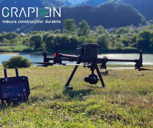
Montreux, Switzerland – TOPODRONE, a Swiss based designer and manufacturer of high-precision surveying equipment, and Graphein, an EU service integrator for the construction industry, recently had a use case on the Surduc Dam inspections (EU) with the aerial TOPODRONE LiDAR 200+.
Exodigo , the artificial intelligence (AI) innovator modernizing underground mapping, today announced the close of a $105 million Series A round, converting $30 million previously secured in SAFEs, for a total of $118 million in funding since its launch in 2022.
McCarthy) one of the largest and most diversified construction companies in America for over 160 years and HOK , a global architecture firm and leader in healthcare design, today announced the groundbreaking of Kedren Childrens Village for Kedren Community Health Center Inc. McCarthy Building Companies, Inc.
Based in Romania, Graphein is a service integrator for the construction industry–supporting engineering, surveying, 3D scanning and modeling, and building behavior monitoring–and an Autodesk partner. Sueran says the project has put his team and equipment to the test, but, by relying on the best products, these difficulties are surmountable.
Trimble Catalyst Now Integrates with Radiodetection’s RD Map+ Application and Precision Locators to Bring Survey-Grade Accuracy to Utility Workflows in North America WESTMINSTER, Colo. — Trimble (NASDAQ: TRMB) and Radiodetection announced today a collaboration to improve the technology used in the utility measurement and mapping process.
In the world of construction, time is money. One of the most common causes of delays, damages, and even safety hazards on construction sites stems from one fundamental issue: unknown or incorrectly mapped underground utilities. This is where utility mapping comes into play.
ConstructionPro Network unveiled today it's Drone Services and Equipment Directory for the construction, transportation, utility and real estate development industries. The directory is intended to assist those looking for vendors and products specifically designed to serve these industries. Read more.
Callahan, Contributing Editor P art 1 of this series addressed how home building lags other industries in achieving productivity gains and how simplification and standardization are key to improving productivity in housing construction. 3 Ways to Automate Residential Construction and Increase Productivity 1.
If you haven't yet checked it out but have an interest in getting some aerial photos or videos of your construction project, visit the Drone Services and Equipment Directory at the ConstructionPro Network website today. Customers can quickly find FAA333 exemption holders serving their states.
The team of 10 professionals, along with state-of-the-art equipment, has a dedicated location within the Latitude 33 headquarters. Capabilities Latitude 33’s Survey Department offers a full suite of services required throughout the life cycle of a development project, including Mapping, Design Surveys, and Construction Staking.
New Holland Construction has appointed Brian Weisbaum, a CNH veteran who has led several initiatives for both CNH construction brands, as the new Head of New Holland Construction, North America. Both our brand and our dealers can be proud that over the past four years we have put the New Holland brand back on the map.
Keeping tabs on your constructionequipment can be a real game-changer. Whether you’re running a small contracting business or managing a large construction site, knowing where your machinery is and how it’s performing is crucial. But how do you go about tracking all that heavy equipment?
Transporting construction materials requires you to overcome complex logistical hurdles beyond simply transportation. Construction managers and site planners can be better prepared to meet deadlines, adhere to regulations, and maintain equipment safety by understanding these obstacles for themselves.
Exodigo , the artificial intelligence (AI) innovator modernizing underground mapping, today announced the close of a $105 million Series A round, converting $30 million previously secured in SAFEs, for a total of $118 million in funding since its launch in 2022.
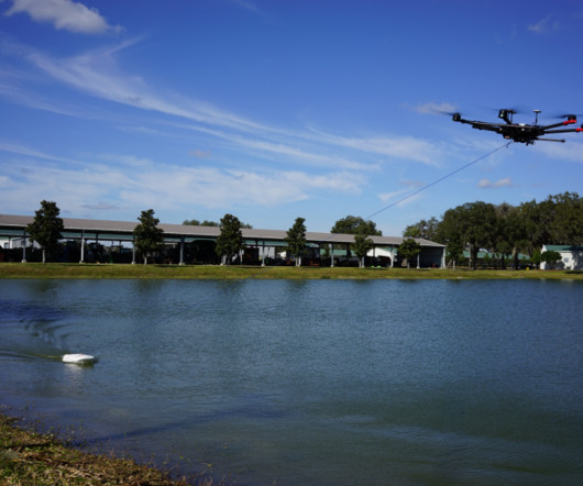
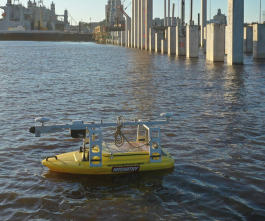
The current process to gather data for new underwater construction or the inspection of existing assets such as bridges, docks, and levees consists of manual surveying from divers or survey sensors mounted to a boat. The vessel is equipped with a COTS sonar unit mounted on its bottom.
In this session, attendees will learn how to use PIX4Dmatic, PIX4Dsurvey, and PIX4Dcloud for drone-based mapping, and to deploy terrestrial workflows with PIX4Dcatch and the viDoc RTK Rover for ground control and ground-based reality capture. This presentation will highlight the importance of drone education in driving growth in the industry.
How can construction companies maintain healthy cash flow while minimizing overhead costs in today’s dynamic industry? Construction companies must adopt proactive cash flow management strategies to thrive in this environment. Additionally, timely equipment maintenance can prevent costly breakdowns, which are costly.
Drone mapping has become a valuable tool in construction, changing how projects are planned and carried out. By taking high-quality images of the land and site conditions, drone mapping helps identify and address potential problems early in the project. Switching from manual surveys to drone mapping greatly improves efficiency.
Construction Methods. Construction Technology. Construction Schools. Construction Groups See Bright Spots in MAP-21s Details. Description: Construction groups like provisions affecting pavements, innovative project delivery, P3 model contracts, stormwater control, among others. site map |.
By Luke Carothers Along the Texas Gulf Coast, the construction and expansion of ports is a continually-active process. McCarthy has continually worked with Port Houston for 30 years, and is currently undertaking projects for Port Freeport as well as demolishing and constructing a strategically important dock for Port Beaumont.
Photo by Pixabay: www.pexels.com "Using drones in construction is no longer futuristic but a reality that is reshaping the industry." Using drones in construction is no longer futuristic but a reality that is reshaping the industry. Why Real-Time Monitoring is Essential in Construction Projects In construction, time is money.
In the ever-evolving landscape of the construction industry, where precision meets creativity and innovation, effective marketing strategies are paramount for attracting top-tier talent across diverse construction job categories. Architects Design and plan construction projects, considering both aesthetic and functional aspects.
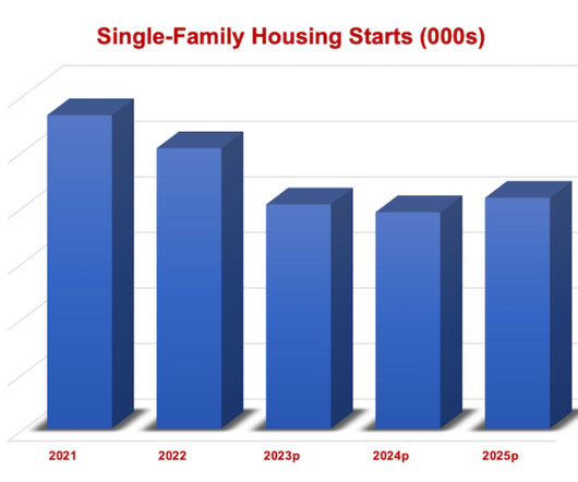
The result will be a multi-billion-dollar drop-off in revenues in categories ranging from appliances to heating and cooling equipment to windows. The map below illustrates the concentration of single-family construction in U.S. This "heat map" of U.S. according to a recent report by market forecasting firm Senex.
By Garrett Harley, Product Marketing Director, Oracle Construction & Engineering As the world pivots into a new, AI-powered future, many industries are changing rapidly to accommodate new tools and new capabilities. One long-entrenched process—creating the schedule—is an area that has long been in need of a makeover.
While bricks and hammers remain, technology has constantly evolved and truly transformed the construction industry. Today’s construction technology is more advanced than ever. From cameras to sensors, we explore some of the most cutting-edge construction hardware transforming the future of the industry. . Risk and safety.
In commercial construction , precision drives perfection. Through careful calculation of pressure points and load-bearing patterns, designs can accommodate everything from pedestrian traffic to heavy equipment. Structural Grid Mapping Creating perfectly aligned patterns starts with establishing accurate reference grids.
Exhibitor demonstrations in state survey society meetings is another good place to observe and test new equipment. More accurate versions are offered for construction design application–e.g., Their added functionality makes them suitable for intense mapping. Step 1: Gather the Survey Equipment, Stake, and Tools.
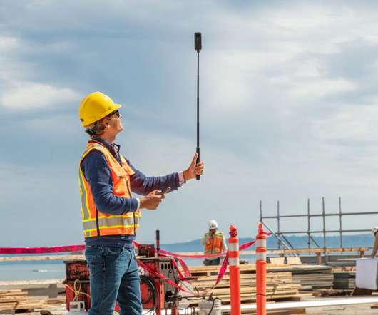
Consumer-level unmanned aerial vehicles (UAVs) can be purchased off the shelf and be up in the air as soon as the batteries are charged, but the data-driven world of construction surveying often demands something a bit more robust. Many companies are already offering their own drones that are tailored to the needs of construction surveying.
The post The 3 Ways That Drones Are Transforming The Construction Industry appeared first on UK Construction Blog. The construction industry is changing all the time. One emerging technology is the use of drones in construction. In this article, we will go over several ways that drones are being used in construction.
Closing deals is imperative to success in any industry, but it’s most true in construction, where projects are often very high-stakes and competitive. It is a step-by-step guide providing construction companies with actionable insights on closing more deals.
Construction sites these days have no shortage of data: design and BIM data from the planning stages of a project, jobsite data collected by wearables, mobile devices and sensors on equipment/materials, accounting and job progress data from the office, project management data and much more. Diving Deeper into Construction Data.
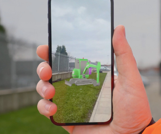
Do you work in a construction company? What are the things you considered before and after a construction site is built? This is the most common question by several companies and establishments that want to add another construction site in a different environment. How to see the underground before starting a project?”
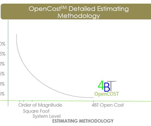
2020 Guide to Construction Cost Estimating provides a road map for applying best management practices necessary to drive financial visibility and transparency. Locally researched detailed line item unit price construction data provided the highest level of verifiable and transparent information. Equipment Costs.
Construction Methods. Construction Technology. Construction Schools. Contractors Are Renting Rather Than Buying More Equipment During Slow Recovery. Equipment rentals allow contractors to shift downtime risk while trimming expenses, including licensing, insurance, taxes and debt, among others. Building Types.
Construction Methods. Construction Technology. Construction Schools. Construction methods & equipment. FREE — ENR’s Greatest Construction Projects with your paid subscription. site map |. Building Types. Sustainability. Haiti Reconstruction. Economic Stimulus. Safety & Health.
Next-frontier automation technology from Teleo is also getting a lot of interest and can be retrofitted to a wide range of heavy equipment.” The MC-Mobile solution includes the Topcon LN-150 construction total station, machine sensors and a versatile Android tablet. Image: Aptella.
Developed in part with research and funding from the Department of Energy’s Building America program , this standard sets minimum requirements for airflow rates for ventilation equipment in residential buildings, and it has been adopted by many states and home performance programs, including Energy Star. She lives in southern Oregon.
It requires a ton of effort in order to avoid damage to the equipment. Aside from that, they require an experienced heavy equipment moving company to move the freight safely. . Knowing the dimensions and weight of the equipment that’s going to be transported is extremely critical to figure out the right logistics of the move.
An efficient organization will gain a competitive advantage over its rivals by doing more in less time and getting the most value out of staff and equipment. Efficiency is also vital in the construction industry. Efficiency across multiple sites Many construction firms will need to operate across multiple sites.
Construction Methods. Construction Technology. Construction Schools. Construction methods & equipment. FREE — ENR’s Greatest Construction Projects with your paid subscription. site map |. Building Types. Sustainability. Haiti Reconstruction. Economic Stimulus. Safety & Health.
This free app is available both to customers and the public, setting a new standard for enhanced project efficiency and sustainability in equipment planning and utilisation. This not only supports the equipment planning phase and placement, it ensures precision and ease when making decisions on the right equipment to hire.
Construction Methods. Construction Technology. Construction Schools. Construction methods & equipment. FREE — ENR’s Greatest Construction Projects with your paid subscription. site map |. Building Types. Sustainability. Haiti Reconstruction. Economic Stimulus. Safety & Health.
We don’t need to tell you that planning and executing construction projects call for a lot of moving parts and coordination. There are budgets to manage, timelines to hit, stakeholders to align—and, of course, a whole lot of construction assets to track. checklists, schedules, etc.),
Construction Methods. Construction Technology. Construction Schools. Construction methods & equipment. FREE — ENR’s Greatest Construction Projects with your paid subscription. site map |. Building Types. Sustainability. Haiti Reconstruction. Economic Stimulus. Safety & Health.
We organize all of the trending information in your field so you don't have to. Join 79,000+ users and stay up to date on the latest articles your peers are reading.
You know about us, now we want to get to know you!
Let's personalize your content
Let's get even more personalized
We recognize your account from another site in our network, please click 'Send Email' below to continue with verifying your account and setting a password.


Let's personalize your content