This site uses cookies to improve your experience. To help us insure we adhere to various privacy regulations, please select your country/region of residence. If you do not select a country, we will assume you are from the United States. Select your Cookie Settings or view our Privacy Policy and Terms of Use.
Cookie Settings
Cookies and similar technologies are used on this website for proper function of the website, for tracking performance analytics and for marketing purposes. We and some of our third-party providers may use cookie data for various purposes. Please review the cookie settings below and choose your preference.
Used for the proper function of the website
Used for monitoring website traffic and interactions
Cookie Settings
Cookies and similar technologies are used on this website for proper function of the website, for tracking performance analytics and for marketing purposes. We and some of our third-party providers may use cookie data for various purposes. Please review the cookie settings below and choose your preference.
Strictly Necessary: Used for the proper function of the website
Performance/Analytics: Used for monitoring website traffic and interactions
What Is a Total Station in Surveying? The most frequently used surveying instrument today is the total station (As per below figure No1). When the Digital theodolite has been used with a built-in electronic distance-measuring unit, the birth of this new concept in fully automated surveying started.
— Trimble (NASDAQ: TRMB) and the Trimble Foundation Fund have partnered with The HALO Trust, the world’s largest landmine-clearing non-profit organization, to help expand its demining operations across Ukraine. The Trimble Foundation Fund is aligned to the company’s commitment towards building a more sustainable future.
If you’re looking to purchase a property or building for your business, most financial institutions require you to have a property survey to qualify for their loans. When buying a property, having a survey helps you identify potential issues for using the property the way you intend, either by building or expanding.
The Foundations of Accurate Planning Accurate planning begins with a thorough understanding of the construction site. Land surveys are an essential component of this phase. These surveys provide precise data on property lines, topography, and existing structures.
By Josh Rayburn Unpiloted systems continue transforming civil and structural engineering by improving efficiency, accuracy, and safety while empowering civil and structural engineers to control costs. Modern unpiloted systems include robotics with sensors that can be deployed on a schedule and a specific path.
The data is from NAHB's construction cost survey, published in 2023, which presents national averages (rather than a specific geographical breakdown) and shows the total construction costs for the “average” single-family home. It’s followed by “excavation, foundation, concrete, retaining walls, and backfill” at 10.1%
McCarthy used an unmanned hydrographic survey vessel to assist in the identification of the underwater dock debris and used divers and cranes to remove all remaining debris. The concrete piles provide a corrosion-resistant foundation for extended resiliency, as well as a final concrete topping slab using synthetic concrete reinforcing fibers.
When implementing backyard interlocking and design solutions , success lies in the mathematical foundations. Modern residential backyard interlocking systems have evolved far beyond simple paver placement, incorporating advanced geometric principles that ensure flawless execution.
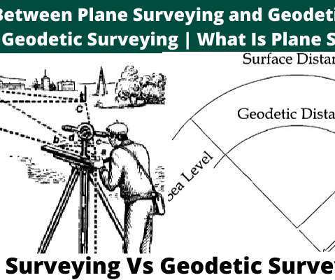
What Is Geodetic Surveying? The geodetic surveying is that type of surveying which takes into account the curvature of the earth’s surface for achieving high precision using principles of geodesy. What Is Plane Surveying? Geodetic Surveying Vs Plane Surveying. National Geodetic Survey.
What Is Geodetic Surveying? The geodetic surveying is that type of surveying which takes into account the curvature of the earth’s surface for achieving high precision using principles of geodesy. What Is Plane Surveying? Geodetic Surveying Vs. Plane Surveying. National Geodetic Survey.
To establish what exactly was underwater, McCarthy utilized divers as well as an unmanned survey vessel (USV) enabling them to maneuver safely and efficiently. Once the area had been surveyed, McCarthy used punches, demolition tools that could be dropped into the water to break up the debris into more manageable pieces before removal.
By Ricardo Aguirre, CEO Steam systems serve as the backbone of numerous industrial processes, providing the essential thermal energy required for a wide range of applications across various sectors. To address these challenges, American Plant Maintenance (APM Steam) offers specialized services aimed at optimizing steam systems.
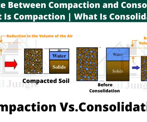
Consolidation occurs naturally due to the structural load from the foundation. Consolidation is a natural process where soil below the building and other structures compacted by the transferred load to the soil through the provided foundationsystem. The foundation settlement will be reduced.
raSmith, a multi-disciplined civil and structural engineering and surveying firm, is proud to announce that four of raSmith’s cold-formed steel engineering projects have garnered recognition, receiving Design Excellence Awards from the Cold-Formed Steel Engineers Institute (CFSEI). BROOKFIELD, Wis.
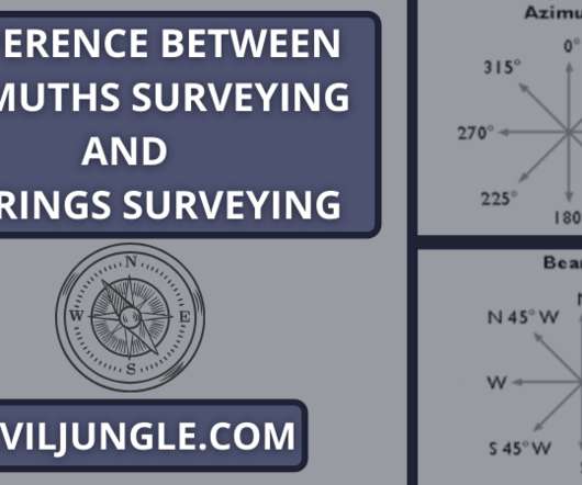
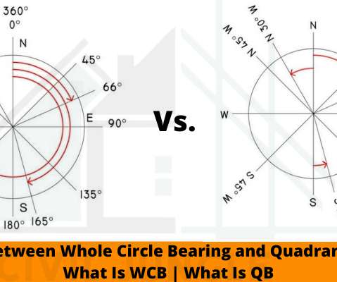
What Is Azimuths Surveying? Azimuths are also called whole circle bearing systems (W.C.B). Azimuths are used in compass surveying , plane surveying , where it is generally measured from the north. What Is Bearings Surveying? Difference Between Azimuths and Bearings in Surveying.
The post The Importance of Topographical Surveys in Construction Planning appeared first on UK Construction Blog. In the realm of construction, the foundation of a successful project lies in meticulous planning and accurate data. Moreover, topographical surveys help in planning drainage systems effectively.
Yet, many businesses and property owners underestimate the importance of measured building surveys , often skipping them to cut costs or speed up the project timeline. Below, we explore six major problems that can arise when you skip a measured survey for your office building.
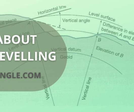
Levelling is one of the most important parts of surveying before starting the construction of roads , dams , or any other structures. It is a branch of surveying which deals with the measurement of the elevation of the point with respect to the datum level above or below the surface of the ground. What Is Levelling in surveying?
“His strong educational foundation combined with extensive professional experience positions him well to contribute significantly to our firm.” For more information about McKim & Creed, visit www.mckimcreed.com.
The project team, led by STV as the overall task lead and subconsultant to Chen Ryan Associates (CRA), will design plans to replace the existing TPSS while minimizing impacts and delays to the system, maintaining the operational efficiency of MTS’s extensive 65-mile track network and keeping the system’s 300,000 weekday trips on schedule.
Space Camp and $7,500 for its school’s STEM program (provided by Finals sponsor Bentley Systems, Inc.). Both schools receive $750 for their organization’s STEM programs, sponsored by NCEES (National Council of Examiners for Engineering and Surveying). NCEES , PMIEF , and the Overdeck Family Foundation.
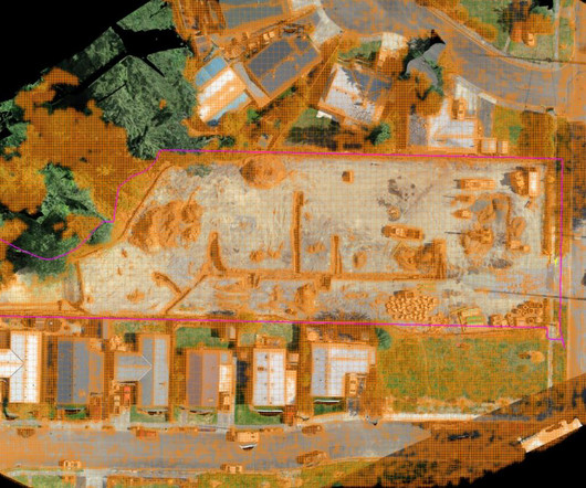
The success of any project heavily relies on accurate surveying, which forms the foundation for precise measurements, proper planning and seamless execution. Let’s immerse ourselves in the accuracy and efficiency of multi-site construction surveying, exploring the latest tools and methodologies that are shaping the industry.
In preparation for potential challenges, the National Right to Work Legal Defense Foundation has created a task force to defend Snyder’s action. Ninety percent of surveyed executives reported that their companies are committed to environmentally sustainable practices. Similar bills have been introduced in 12 other states.
How Do You Build a Solid Digital Foundation? Starting with a strong digital foundation is key because construction involves complex projects with multiple moving parts and a ton of data. Tech solutions like drones and 3D scanning also make it possible to survey potentially dangerous areas without putting workers at risk.
The small footprint left little space for staging, and the geometry of the primary habitats meant that formwork coordination and prefabrication efforts would need to account for the numerous life support systems (LSS) and embedments prior to site delivery. The integration of software and hardware made this process very efficient and accurate.
The structures comprise of a monopile foundation and internal grouted jacket, each monopile weighs in excess of 30t and has an embedded depth below seabed of 30m. Navigation lights and systems were also installed. Each structure is purpose-built, bespoke, and specific to the landscape characteristics of each location.
Then after architect consult with a structural engineer and MEP engineer for details of the reinforcements and other detail for use, how deep your foundation will be, the size of gravel to be used, column width, electrical, plumbing, etc. Land Survey. Foundation. I.e., the size of the foundation , depth, width, and length, etc.
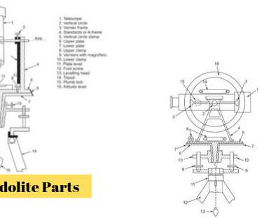
Distance between two points (in a small area) is measured in chain survey. Horizontal angles between stations and objects are obtained in a compass survey with an accuracy of half a degree. Trigonometric leveling and tachymetric surveying are the two immediate examples of utilizing theodolite work, in addition to traversing.
According to KPMGs 2015 Global Construction Survey , a staggering 69% of projects experienced cost overruns of 10% or more. Rabbets centralized data foundation eliminates these inefficiencies, enabling teams to prevent overruns before they occur. Cost overruns are a pervasive challenge in the construction industry.
3 Survey results are publicly reported, so they greatly influence an organization’s reputation. 3 Survey results are publicly reported, so they greatly influence an organization’s reputation. Additionally, the government allocates reimbursements based on results, so the survey directly impacts a hospital’s financial performance.
Concerns around labor shortages, stagnation and recession, and the political climate all featured prominently among the biggest construction industry challenges in InEight’s recent Global Capital Projects Outlook survey. Others have pinpointed spiraling labor costs, inflation, and interest rate rises as major risks on the horizon.
Data integration platforms facilitate faster connections between digital twins and IT/OT systems. The foundational data for digital twins are generated during design and construction processes. Richer built-in software functionality enables customers to deploy digital twin platforms with less customization. And for good reason.
To tackle these concerns, roughly half of the civil contractors and civil engineers surveyed said they would allocate more resources toward recruitment. Paper forms manually completed must be entered into a system to allow for impactful analysis, opening the door to potential mistakes. Only then can we start to make the jobsite safer.
Through automating routine inspections, drones streamline tasks that would otherwise require human intervention, such as surveying large plots of land or tracking the progress of structures. Drones provide unmatched accuracy when surveying land, mapping terrain, and capturing detailed measurements.
This ambitious project–owned by the Egyptian National Authority of Tunnels (NAT)–is intended to create a direct connection between Cairo, the New Administrative Capital, and 6th of October City via a two-line rapid transit system. When completed, this will be the longest driverless monorail system in the world.
Whole circle bearing(WCB) and Quadrantal bearing(QB) are the two types of bearing which is used in the field of surveying for the purpose of measurement of the bearings. If the survey line falls between the first quadrant then the Whole Circle Bearing lies between the 0° to 90°. • Introduction of WCB Vs. QB. Whole Circle Bearing. •
That number rises as high as 25-33 percent for people living in certain areas along the BeltLine as sourced through the American Community Survey. eX² Technology manages and maintains the communications system as well as serves as the BeltLine’s exclusive commercialization partner. eX² Technology designed and installed a 15.7-mile
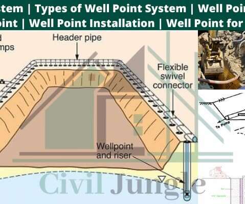
The flexbow incorporated in the riser pipe acts as an adjustable valve which serves two purposes, firstly it controls the flow of water and air entering the Well Point system, and secondly it allows others to have a clear view of what is being pimped. A Well Point system consists of several closely spaced shallow wells of small diameter.
What is a Raft Foundation? A raft foundation , also called a raft foundation , is essentially a continuous slab resting on the soil that extends over the entire footprint of the building, thereby supporting the building and transferring its weight to the ground. . Types of Foundation. Shallow foundations.
Source: UK RAC Foundation. After surveying all U.S. Incorporating a quality waterproofing system to protect aging bridges for the long term is essential in reducing ongoing maintenance and subsequent bridge closures. . Some important factors to consider when comparing waterproofing systems include: . billion RMB.
When I wrote my book, “Construction Collaboration Technologies: An Extranet Evolution”, in 2005, I looked forward to a rosy collaborative future encompassing BIM, real-time collaboration, mobile technologies, and rich integration with back-office and others systems. to a typical project budget ”.
The post House Foundation Depths: UK Guide to Building Regulations & Requirements 2025 appeared first on UK Construction Blog. Key Takeaways House foundations in the UK typically range from 0.6 Tree proximity affects foundation depth requirements, with large trees (over 15m tall) necessitating minimum depths of 2.0m
As we dive into the various types of shuttering materials and techniques, prepare to be amazed by the innovative systems that enable complex and unique structures to come to life. Best practices for shuttering in construction include proper surveying, planning, formwork removal, quality control and inspections.
Flooring is the foundation of any interior, visually and functionally setting the tone for the space. The national, standardized Hospital Consumer Assessment of Healthcare Providers and Systems (HCAHPS) survey provides healthcare systems insight into patients’ perceived care.
We organize all of the trending information in your field so you don't have to. Join 79,000+ users and stay up to date on the latest articles your peers are reading.
You know about us, now we want to get to know you!
Let's personalize your content
Let's get even more personalized
We recognize your account from another site in our network, please click 'Send Email' below to continue with verifying your account and setting a password.


Let's personalize your content