This site uses cookies to improve your experience. To help us insure we adhere to various privacy regulations, please select your country/region of residence. If you do not select a country, we will assume you are from the United States. Select your Cookie Settings or view our Privacy Policy and Terms of Use.
Cookie Settings
Cookies and similar technologies are used on this website for proper function of the website, for tracking performance analytics and for marketing purposes. We and some of our third-party providers may use cookie data for various purposes. Please review the cookie settings below and choose your preference.
Used for the proper function of the website
Used for monitoring website traffic and interactions
Cookie Settings
Cookies and similar technologies are used on this website for proper function of the website, for tracking performance analytics and for marketing purposes. We and some of our third-party providers may use cookie data for various purposes. Please review the cookie settings below and choose your preference.
Strictly Necessary: Used for the proper function of the website
Performance/Analytics: Used for monitoring website traffic and interactions
This partnership will integrate Propeller’s powerful mapping and data visualization capabilities with HCSSs suite, including HeavyBid, HeavyJob, HCSS Plans, and HCSS Cloud, creating a seamless experience for joint users.
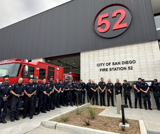
San Diego, CA – On October 17, 2024, Latitude 33 Planning & Engineering joined officials from The City of San Diego, UC San Diego, The Muller Hull Partnership, Level 10 Construction, and other stakeholders at a Grand Opening ceremony for San Diego Fire Station 52 (also known as the Torrey Pines Fire Station).
It will also include remediating a large, previously unusable brownfield site so that it can be used for greenspace. Plans call for adding a 10-foot multi-use path and buffered bicycle lanes on the north and south sides of the road, plus a sidewalk on the south side. Other project components, however, are still being designed.
Construction leaders have committed to eliminate diesel from most sites by 2035. The Construction Leadership Council’s CO2nstruct Zero task force has published a broadly based route map towards diesel-free operation as part of the wider plan to decarbonise the industry.
SUGAR LAND, TX: HCSS, a leading provider of innovative software helping heavy civil construction businesses streamline their operations, highlights HCSS Plans, a digital plans management solution ideal for construction job site foremen in the field.
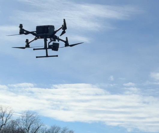
This innovative initiative enhances pre-project planning, improves construction visibility, boosts safety measures and increases operations efficiencies. We are also able to use the drone to obtain existing topographical information enabling us to make preliminary plans and prepare earthwork budgets early in the project design process.
Defintion A map is a visual drawing of a whole region or some of a locality that’s often shown on a flat surface. What is Map? A map’s purpose is to depict precise and elaborated aspects of a particular location, most ordinarily want to show geography. There are many types of maps, together with static, […].
Fortunately, the implementation of off-site construction practices is one approach that can help solve these challenges. One off-site construction trend that has seen a significant rise in popularity is the production and use of prefabricated accessory dwelling units (ADUs). What Are Accessory Dwelling Units (ADUs)?
Without proper planning, even the best-designed commercial construction projects can face delays, cost overruns, or legal issues. With a competitive landscape and unique local challenges, precise planning becomes critical. With a competitive landscape and unique local challenges, precise planning becomes critical.
Ways to Improve Home Building Productivity, Part 2: Automation ibush Thu, 02/15/2024 - 15:31 Home builders can maximize efficiencies gained through simplification and standardization by automating both on-site and back-office operations Tony L. Consider the potential benefits of off-site construction to your current home building process.
Imagine a robot, something like a combination Roomba vac and magic marker, that could translate complex construction drawings onto the ground, leaving an error-free map for building crews to follow. Body Image: read more. Architects Contractors Designers Engineers Building Technology'
San Diego, CA – Latitude 33 Planning & Engineering has announced that Phase 1 for the $60 million Bonsall development, The Havens , is under construction. The master-planned community in San Diego County offers unprecedented open space and unique amenities. Two decades ago, the site was initially approved for large estate lots.
Conducting Effective Site Surveys: Tools, Techniques, and Best Practices Discover the essential steps, tools, and techniques for conducting effective site surveys. From planning to data collection, master the process!
She has extensive experience designing and managing both public and private projects in challenging geotechnical environments including civil infrastructure, multi-use urban infill projects, high-rise buildings, excavation and shoring, master-planned communities, hillside grading, and shoreline redevelopment projects.
Homebuilding Data Analytics Higharc automates the flow of information about home plans among the various homebuilding departments and stakeholders—from permitting officers to tradespeople to salespeople. A new home design can inherit pattern rules and map them onto its floorplan.
The eight “mission” types that Uplift flies include construction and thermal inspection, as well as real estate surveying and mapping. In early 2016, Clayco, the Chicago-based design-build contractor, launched Uplift Data Partners, a full-service provider of drone technology and remote pilot training.
New updates to the software include the ability to calculate and model an optimal flattened siteplan in the terrain, plot the least cost path across a landscape, and significantly improved processing speed in pixels to points tool.
One of the most common causes of delays, damages, and even safety hazards on construction sites stems from one fundamental issue: unknown or incorrectly mapped underground utilities. This is where utility mapping comes into play. Imagine breaking ground on a new project only to discover a major water main beneath the site.
A new mobile application for iOS devices allows users to pin siteplans to their location on Earth by integrating with Apple Maps. Then, they can take site photos and make annotations and markups on the plans.
He brings a year of internship experience to his role at T&H, having worked as a senior for a local site development firm. Lars has nearly a decade of experience in drafting, graphics, and design in nuclear drafting, transmission and distribution, audio video design, civil/site development, and underground internet/fiber cabling design.
He mapped out how organizations responsible for these large capital projects can tap into the potential of that data by using enterprise GIS and location intelligence. And pulling asset data and related information into a location-based format—a map—would make it easy for stakeholders to find and view the necessary information.
(the “Company” or “Bowman”) (NASDAQ: BWMN) was contracted by Midway Rising to deliver engineering, survey and mapping services for a new entertainment center and master plan for San Diego’s Midway-Pacific Highway community. The master plan also includes 4,250 housing units to include 2,000 designated as affordable housing units.
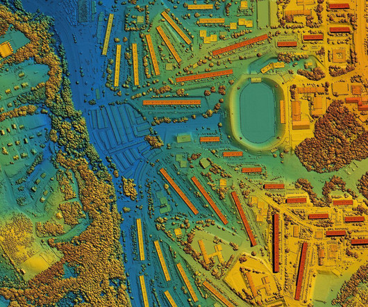
Drone mapping has become a valuable tool in construction, changing how projects are planned and carried out. This technology provides accurate surveying and fast data collection, allowing professionals to see project sites from an aerial view. Switching from manual surveys to drone mapping greatly improves efficiency.
Poor planning leads to, well, poor performance. In an ideal world, we would have the same thousands of experts and years of time to plan all conceivable permutations of the disaster to develop an appropriate disaster response plan. Floodbase provides WFP Zimbabwe with emergency maps of forecasted flood events. The sewers?
4 considerations for increasing biodiversity in construction projects 0 qpurcell Thu, 05/25/2023 - 09:39 Urban Planning As climate change is linked with biodiversity depletion, fostering biodiverse landscapes during construction can create benefits beyond the immediate surroundings of the project.
Urban designers and planners frequently consult 3D imagery from Google Earth and other online mapping services to get a sense of existing site conditions. If you’ve used Google Earth or Apple Maps recently, you’ll notice that the 3D imagery is increasingly realistic.
With traditional methods, supervisors must physically inspect sites or rely on outdated reports, often leaving information gaps. The enhanced visibility over the entire site helps ensure that projects run smoothly and efficiently. With this in mind, drones offer a solution that minimizes human risk while improving site safety.
Architecture firm, Marvel, the developer, Phipps Houses, and NYC’s Department of City Planning are all collaborators on the project. The eight design principles, demonstrated in Figure 1 (the road map), guide the project, resulting in a diverse set of buildings prioritizing functionality over symmetry.
The schedule is the beating heart of every project, providing the road map that every team member will base their work around. The more members that are added to the project team, the more mature the schedule should become, adding depth and establishing a more thorough plan for every member of your team.
By Matt Desmond, President AGTEK, Vice President Heavy Construction, Construction Management Solutions at Hexagon Estimates aren’t just a “necessary evil” in the process of creating bids and design plans; they also ensure projects stay on track by offering a baseline to compare construction project activity—or a scoreboard—to measure success.
These beams were precisely assembled on-site, achieving a remarkable margin of error of less than 1-mm. The structure’s dome is composed of 277 unique triangles made from CLT produced at Stora Enso’s Gruvon site in Sweden. For the Wisdome project, the total construction time was one year and ten months.
As well as being corrosion proof, it is flexible and ductile to go through a special die on the job site that makes it possible to be pulled inside a host pipe even when the pipe is not round. There is a $215 million expansion plan underway that will increase the facility’s capacity by 50 percent when completed in 2025.
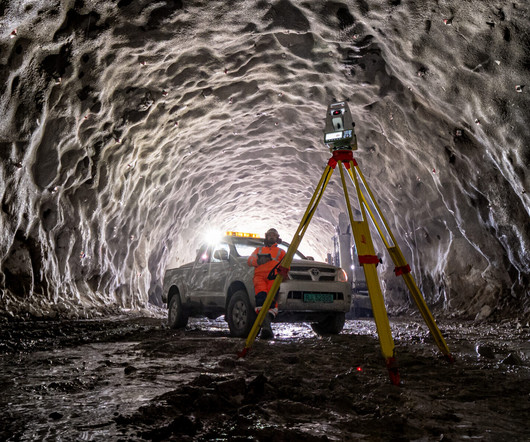
We plan and prepare as best we can but the unpredictable nature of geology can surprise us at any moment. With the different sites and dynamic nature––literally––of the project, we wanted to adopt technology that would enhance tunneling efficiency and tracking, reduce downtime and streamline data flows.”
The team applied laser scanning for the initial design and on-site comparison of the as-built situation with the data model in Tekla Structures. The model was shared between the two companies using Tekla Model Sharing and used in a ‘live’ situation, with workers on site having the models both on tablets or mobile phones and on paper.
In simplest terms, to get environmental approvals, agency regulators need the answers to three questions: What resources are at the site? Site Selection and Impact Assessment The initial step in the solar environmental permitting journey involves meticulous site selection and impact assessment. What are the potential effects?
That said, this article will unravel strategies that resonate with professionals, from those who meticulously plan projects to those who wield the tools on-site. Project Managers Responsible for overseeing the planning, execution, and completion of construction projects. Ensure equipment is maintained and used safely.
When it was first introduced in 2010, it started to rapidly replace the need for paper-based plans and processes. They’ve been used across various industries, but as they have become more innovative and advanced, they’ve become irreplaceable on a construction site. . Take the iPad, for example. 1: Construction Cameras.
Therefore, improving financial planning is key to discovering innovative ways to reduce overhead, all while enhancing overall efficiency and performance. Strategic Financial Planning Adopt Advanced Financial Forecasting Tools Construction organizations have to be competitive in outlook, hence requiring good financial forecasting tools.
Develop a marketing plan with objectives, action calendar and measures. Search optimize your website with all search engine optimization (SEO ) features (meta coding, sitemaps, reviews, etc.). Aggressive networking with associations (local/gregional, AGC, ASA, BOMA, AIA, etc).
This allows users to choose the method that best suits their needs or as dictated by site conditions. Optional Trimble Protected Plus and Premium protection plans are also offered. Able to operate on 450 MHz, 900 MHz or LTE bands, users have flexibility in how they receive and transmit RTK corrections.
Construction managers and site planners can be better prepared to meet deadlines, adhere to regulations, and maintain equipment safety by understanding these obstacles for themselves. Efficient scheduling is the only way for you to prevent project delays because construction sites often operate under tight deadlines.
Learning how to prepare a construction plan can take years and multiple projects before you are exposed to enough information. With that said building a construction plan is simple if you use these easy to follow steps. What Is A Construction Plan? When Should I Develop The Plan and Who Should Be Involved?
What are the things you considered before and after a construction site is built? This is the most common question by several companies and establishments that want to add another construction site in a different environment. Where to Get Underground Utility Plans? How to see the underground before starting a project?”
Search our site: Infrastructure. MAP-21 Toughens Buy America Requirements, U.S. The newly enacted MAP-21 transportation bill has provisions that their advocates say will fortify "Buy America" requirements for highway and transit projects. The other "Buy America" revision is in MAP-21’s transit section. contact us.
We organize all of the trending information in your field so you don't have to. Join 79,000+ users and stay up to date on the latest articles your peers are reading.
You know about us, now we want to get to know you!
Let's personalize your content
Let's get even more personalized
We recognize your account from another site in our network, please click 'Send Email' below to continue with verifying your account and setting a password.


Let's personalize your content