This site uses cookies to improve your experience. To help us insure we adhere to various privacy regulations, please select your country/region of residence. If you do not select a country, we will assume you are from the United States. Select your Cookie Settings or view our Privacy Policy and Terms of Use.
Cookie Settings
Cookies and similar technologies are used on this website for proper function of the website, for tracking performance analytics and for marketing purposes. We and some of our third-party providers may use cookie data for various purposes. Please review the cookie settings below and choose your preference.
Used for the proper function of the website
Used for monitoring website traffic and interactions
Cookie Settings
Cookies and similar technologies are used on this website for proper function of the website, for tracking performance analytics and for marketing purposes. We and some of our third-party providers may use cookie data for various purposes. Please review the cookie settings below and choose your preference.
Strictly Necessary: Used for the proper function of the website
Performance/Analytics: Used for monitoring website traffic and interactions
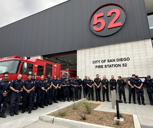
San Diego, CA – On October 17, 2024, Latitude 33 Planning & Engineering joined officials from The City of San Diego, UC San Diego, The Muller Hull Partnership, Level 10 Construction, and other stakeholders at a Grand Opening ceremony for San Diego Fire Station 52 (also known as the Torrey Pines Fire Station).
Conducting Effective SiteSurveys: Tools, Techniques, and Best Practices Discover the essential steps, tools, and techniques for conducting effective sitesurveys. From planning to data collection, master the process!
raSmith, a multi-disciplined civil and structural engineering and surveying firm, is working with developer Wangard Partners on a multi-story mixed-use development at Olympia Fields in Oconomowoc, Wis. Multi-Story Mixed-Use Development Will Be the Latest Addition at Olympia Fields BROOKFIELD, Wis.
. — raSmith, a multi-disciplined civil and structural engineering and surveying firm, has announced the promotion of David Mortensen to director of site design services. Mortensen previously held the position of assistant director of site design services at raSmith.
The digitization of these processes enables greater efficiency and shorter project timelines, and allows environmental consultants to visualize, organize, and analyze data for robust project planning. Award-winning engineering, planning, and consulting firm Freese & Nichols, Inc. Army Corps of Engineers.
SUGAR LAND, TX: HCSS, a leading provider of innovative software helping heavy civil construction businesses streamline their operations, highlights HCSS Plans, a digital plans management solution ideal for construction job site foremen in the field.
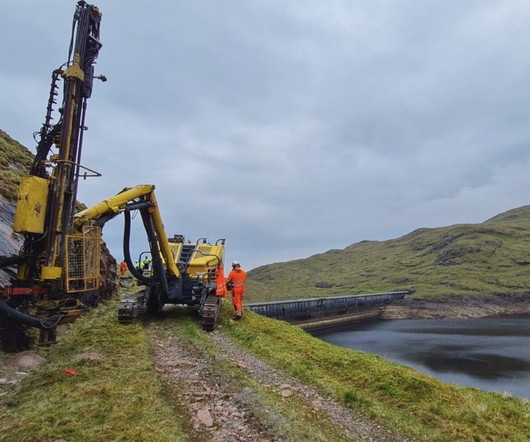
Seismic surveys are underway on the slopes of Ben Cruachan in Scotland where Drax is planning to construct a new 600MW pumped hydro-electricity storage scheme. The post Seismic surveys underway at site of new Ben Cruachan 600MW pumped hydro scheme appeared first on New Civil Engineer.
This innovative initiative enhances pre-project planning, improves construction visibility, boosts safety measures and increases operations efficiencies. We are also able to use the drone to obtain existing topographical information enabling us to make preliminary plans and prepare earthwork budgets early in the project design process.
SAN ANTONIO, TX STV, a leading professional services firm that plans, designs and manages infrastructure projects across North America, today celebrated a major milestone on the Loop 1604 North Expansion project with the opening of the first flyover ramp at I-10. STVs CEI work included the installation of 62,150 tons of concrete, 10.25
. — raSmith, a multi-disciplined civil and structural engineering and surveying firm, has announced leadership changes in its municipal services division. He has managed projects that include sanitary sewer evaluation surveys (SSES), flow monitoring, dye water flooding, and utility and roadway construction/reconstruction.
Without proper planning, even the best-designed commercial construction projects can face delays, cost overruns, or legal issues. With a competitive landscape and unique local challenges, precise planning becomes critical. With a competitive landscape and unique local challenges, precise planning becomes critical.
(the “Company” or “Bowman”) (NASDAQ: BWMN) was contracted by Midway Rising to deliver engineering, survey and mapping services for a new entertainment center and master plan for San Diego’s Midway-Pacific Highway community. The master plan also includes 4,250 housing units to include 2,000 designated as affordable housing units.
Sustainable site design is a hot topic in the AEC industry. As Civil Engineers, Landscape Architects, and Planners, we are challenged to integrate conservation into site design, preserving the natural features of the land. Skilled site designers excel at creating an engaged outdoor environment that meets the needs of the project users.
BALTIMORE, MD STV, a leading professional services firm that plans, designs and manages infrastructure projects across North America, today announced it has signed a contract with East Baltimore Development, Inc. STV provided initial infrastructure planning and design services for EBDI in 2002. Eager Street Ashland Avenue between N.
San Diego, CA – Latitude 33 Planning & Engineering has announced that Phase 1 for the $60 million Bonsall development, The Havens , is under construction. The master-planned community in San Diego County offers unprecedented open space and unique amenities. Two decades ago, the site was initially approved for large estate lots.
The General Survey Act of 1824, signed into law April 30, 1824, authorized Army engineers to chart transportation improvements vital to the nation’s military security and commercial growth through the design of state and private roads, canals, and railroads determined to be of national interest.
Surveying 194 general contractors, architects, engineers and designers working on projects exceeding $30 million, the research conducted by Endeaver Business Intelligence underscores the industrys biggest pain points and highlights opportunities for safer, faster, simpler and more effective construction practices.
Phase one will concentrate on the Queensgate Market site with survey and preparation works completed throughout 2023 and main construction starting next year. As a resident of Kirklees, I hope that this will be another vital piece of the plan, to attract people back to the town centre.
. “We have been able to help this expert partnership deliver their ambitious plans in an affordable way, despite rising construction costs, through the right mix of modern technology and traditional construction methods.” The hub is scheduled for completion in the first half of 2024.
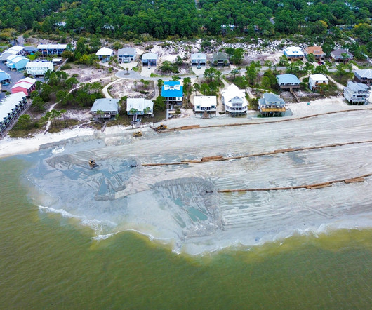
Construction efforts entail the hydraulic placement of more than one million cubic yards of sand to the island’s east end designed by South Coast Engineers (SCE) with Goodwyn Mills Cawood (GMC) overseeing construction, engineering, surveying, environmental and inspections. There are also still plans to install more than 2.5
67% of Irish construction companies report no (48%) or low (19%) involvement in public infrastructure projects, according to the latest CIF Construction Outlook Survey. Industrial and commercial projects account for 44% of planned non-residential work in Q1 2025. 26% report an increase in the number of people they employ.
The post Understanding Construction Surveying appeared first on UK Construction Blog. Integral to this development process is construction surveying, a critical discipline ensuring that all construction adheres to stringent safety and regulatory standards.
He brings a year of internship experience to his role at T&H, having worked as a senior for a local site development firm. Lars has nearly a decade of experience in drafting, graphics, and design in nuclear drafting, transmission and distribution, audio video design, civil/site development, and underground internet/fiber cabling design.
New updates to the software include the ability to calculate and model an optimal flattened siteplan in the terrain, plot the least cost path across a landscape, and significantly improved processing speed in pixels to points tool.
These project components will provide the community with three improved ways of entry into SDSU Mission Valley and Snapdragon Stadium and are critical to the next phase of site development. It’s gratifying to be part of the exciting future of Mission Valley.” It’s gratifying to be part of the exciting future of Mission Valley.”
In late November 2023, Pro Builder partnered with management and consulting company Shinn Builder Partnerships to survey about 400 builders in its network about their use of AI. The Shinn survey asked home builders about the benefits of AI as well. A good example is Arx City. Although just 37 builders responded, 35.1%
A sitesurvey is a critical step in various fields such as construction, real estate, and urban planning. This comprehensive assessment involves the collection and analysis of data about a specific location to inform decision-making and project planning. What is a SiteSurvey? Importance of a SiteSurvey 1.
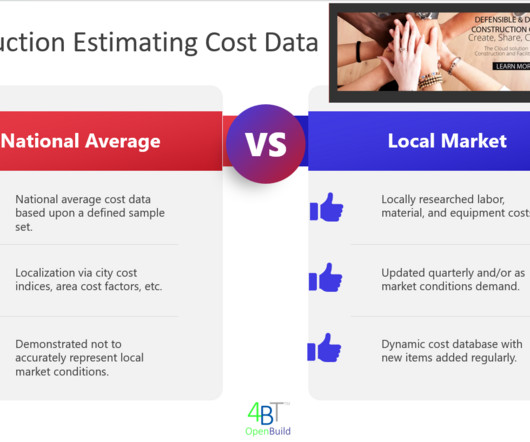
Hidden Site Conditions: Unforeseen site conditions like soil instability or unexpected utilities can lead to significant cost increases if not properly assessed during the initial estimating phase. Regular Market Monitoring: Tracking current material prices and market trends to ensure accurate cost estimations.
The local and national recognition that raSmith received is based on employees’ responses to survey questions about the firm’s workplace culture, benefits, and other related qualities. Companies, such as raSmith, who are named a regional Top Workplace are submitted for consideration of a National Top Workplace award.
McIlheran will assist with leading raSmith’s team of site planners, civil engineers, & landscape architects whowork on projects across the U.S. raSmith, a multi-disciplined civil and structural engineering and surveying firm, has announced the promotion of Paul McIlheran to assistant director of site design services.
raSmith, a multi-disciplined civil and structural engineering and surveying firm, is pleased to announce that Chris Tippery, P.E., BROOKFIELD, Wis. ENV SP, senior project manager, has been named the recipient of the 2023 Collections Award for the Wisconsin Section of the Central States Water Environment Association (CSWEA).
an engineering, surveying, and environmental firm headquartered in Annapolis, Maryland. Its services include engineering design, land surveying, land use and siteplanning, permit processing, stormwater management, environmental consulting, and more. Bay Engineering – together with its affiliate Bay Environmental, Inc.
As part of Montgomery County’s economic development plan, this redevelopment combines open space, public transit, art and culture to form a revitalized space that reflects its vibrant local community. The company is providing civil engineering design, survey and plat development and arborist services for the project’s first three phases.
The post The Importance of Topographical Surveys in Construction Planning appeared first on UK Construction Blog. In the realm of construction, the foundation of a successful project lies in meticulous planning and accurate data. Moreover, topographical surveys help in planning drainage systems effectively.
A topographical survey, which provides a detailed representation of the terrain, is an essential tool for architects. This blog will explore why every architect should consider a topographical survey before diving into the design phase, highlighting the various benefits and practical applications of this critical step.
GIS (Geographic Information System) surveying is a powerful tool that combines traditional land surveying techniques with geospatial technology to create detailed maps and databases. It allows users to organize, visualize, and analyze vast amounts of data for planning new construction projects or maintaining existing infrastructure.
What Is Land Surveying? Landing surveying is all about making maps to help people solve problems with a piece of land, whether it be a property line, what’s out there, where’s the roadway or flood plain. Land surveying provides a drawing that contains the existing conditions of the area and provides the dimensions of the parcel.
Whether for extensive renovation work, property valuation, or facility management purposes, performing an accurate measured building survey is an important part of understanding any real estate asset in London. Coordinating the SiteSurvey The first step in a measured building survey is careful planning and coordination.
Additionally, DeSombre has served in numerous organizations such as the Women’s Transportation Seminar (WTS) and Transportation Improvement Conference (TIC) planning committee organized by WisDOT and the American Council of Engineering Companies (ACEC) Wisconsin.
Chris Tippery, senior project manager with raSmith, a multi-disciplined civil and structural engineering and surveying firm, will participate in the Water Environment Federation’s Technical Exhibition and Conference (WEFTEC) Operations Challenge scheduled for October 2-3, 2023, at McCormick Place in Chicago, IL. BROOKFIELD, Wis.
To preserve the structure and protect it from future flooding events, a plan was created to move the building 32-feet to the east and set about restoring the historic characteristics of the building. Sheridan herself has been coming to the neighborhood since she was a child, and looks back to her memories of the place as a shopping mall.
Komatsu’s Edge 2 is a mobile drone data processing unit that provides a highly accurate and efficient alternative to conventional surveying methods. Komatsu’s Smart Construction Edge 2 solution is transforming conventional surveying methods, offering a more efficient and safer alternative. Images: Komatsu.
The Trimble R980 brings together several top Trimble GNSS technologies to create an indispensable tool for land surveying, transportation infrastructure, construction, energy, oil and gas, utilities and mining projects. This allows users to choose the method that best suits their needs or as dictated by site conditions.
In the realm of multi-site construction, precision and efficiency are essential. The success of any project heavily relies on accurate surveying, which forms the foundation for precise measurements, proper planning and seamless execution.
We organize all of the trending information in your field so you don't have to. Join 79,000+ users and stay up to date on the latest articles your peers are reading.
You know about us, now we want to get to know you!
Let's personalize your content
Let's get even more personalized
We recognize your account from another site in our network, please click 'Send Email' below to continue with verifying your account and setting a password.


Let's personalize your content